FREE UK delivery when you spend £50 - see more delivery options.

Are you looking to buy a outdoor handheld GPS device and/or mapping for one? Want to find a answer to a question that's not answered on our website handheld product pages? This page will help. Look through the list of questions below that customers and visitors have asked. Got a question that's not been anserwed? Then please complete our online form below and we'll answer and add it to our FAQs.
Unit questions
Q. Is the Garmin Oregon 200 compatable with Garmin Bluechart g2 marine charts?
Q. Can I buy the Oregon 550 slip case to use with the new Oregon 600?
Mapping questions
Q. Are there any UK map upgrades available for the Dakota 10?
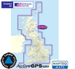
Q. Why are the Garmin GB Discoverer maps on SD card so expensive?
Q. Which handheld device would you recommend to use with marine charts for Greece?
Q. I am trying to decide whether to replace my old Garmin Montana 600 with the new Garmin Montana 700 or the Garmin zumo xt2. Is there much difference in functionality between the units?
A friend of mine has recommended the zumo xt2 because of the satellite views and cross ability to use as a road gps. Is the satellite view also possible on the Montana? I have been very pleased with the ruggedness of the Montana 600.
 A. The Garmin Montana 700 series is first and foremost a handheld unit. However, it can be used on a motorbike or within a car by separately purchasing additional Garmin Montana 700 series accessories.
Both the Garmin Montana 750i and Garmin zumo XT2 utilise BirdsEye satellite imagery.
The Garmin Montana 700 features a 5-inch touchscreen display, whereas the Garmin zumo XT2 features a 6-inch touchscreen display. Both units can be used either landscape of portrait.
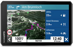 For use on the road, I would agree with your friend, the zumo XT2 wins hands down. The Garmin zumo XT2 is preloaded with MICHELIN Green Guide and Scenic Road. Plus you can use the Garmin zumo XT2 Adventurous Routing setting among others. To choose the best on-screen maps you can also quickly toggle between on-road maps, topographic maps and BirdsEye Direct satellite imagery on the Garmin zumo XT2.
Everything you need to use the Garmin zumo XT2 on your motorbike is included. However, additional and replacement Garmin zumo XT2 accessories are available for use in-car or on a second bike.
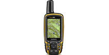
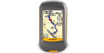
Q. Please advise on the very best Handheld GPS unit for hiking all mountains in the UK. Please also advise me on why it is the best.
A. For the very best I would recommend the Garmin GPSMAP 66s or Garmin GPSMAP 66i.
Why is it the best? It's the latest model, replacing the outgoing GPSMAP 64 series:
GPSMAP 64 series vs GPSMAP 66 series
GPSMAP 64 Series
‣3.5GB storage
‣5,000 waypoints
‣2.6-inch screen
‣160x240 resolution
GPSMAP 66 Series
‣16GB storage
‣10,000 waypoints
‣3-inch screen (1cm bigger screen than the 64 series)
‣240x400 resolution
While there are other Garmin handheld GPS models e.g. Garmin Montana, Garmin Oregon, etc, the GPSMAP 6x series is recognised as the most professional, why?
1. Protruding GPS antenna - better GPS fix and lock in deep valleys, dense wooded areas, etc. Other Garmin handheld models feature a built-in GPS antenna, cover these with a hand, etc and you'll impede the GPS signal.
2. Button control (GPSMAP 6x series) rather than touchscreen display (Garmin Montana, Garmin Oregon, etc). Touchscreen might be perfect in car, but up a mountain in rain or snow and the water contact is going to make the touchscreen struggle at best.
You might like to also consider at this stage if your require Ordnance Survey maps? If you do, there are two titles of Great Britain available:
We can offer bundle prices when buying a Garmin handheld GPS device and map at the same time. Please contact us for more details.
Q. I am looking for a GPS I can use for walking, cycling and off-road motorcycling. I have done some research and the Garmin Montana gets good reviews. I have looked on their web site and it is a bit confusing hence the email to ask your advice. Firstly, I would say that I am not bothered about a camera, but I have notice the 680T has European maps pre-loaded and wondered if this was a better value to buy that say the 610 with a separate purchase map (which the spec. looks the same but without camera and a little less internal memory). Do you know if the 680T map is any good? Or would I be better having a 610 and buying a map. Then what map should I but as I notice Garmin refers to a 1:50k and 1:25k (the latter being twice the price). Then when you get the map on the micro SD card can you download it on the device, so you can have another map like there cycling map on the card?
A. The preloaded map on the Garmin Montana 680t is at a scale of 1:250K to 1:100K scale for Great Britain and mainland Europe. Hence it is not as detailed as the optional TOPO maps that are available.
The best available map for Great Britain is the Garmin TOPO Great Britain 1:25K.
You are right to point out that you can also purchase the Garmin TOPO Great Britain 1:50K.
Mapping supplied on SD/microSD card cannot be download or copied to the device. If you wish to use a different map on preprogrammed SD card you will first need to remove the SD/microSD card from the slot within the Garmin Montana or other compatible device.
Compare the Garmin Montana series.
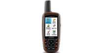
Q. Please could recommend the best Garmin product for walking in the UK. I know that Id like a touch screen but not too small that you cant see it. Other requirements are for an electric compass and altimeter and good quality walking maps to be preloaded or part of a bundle. I dont particularly need a camera as part of the feature list. The key requirement is to be able to clearly see my position of public footpaths whether especially in open countryside.
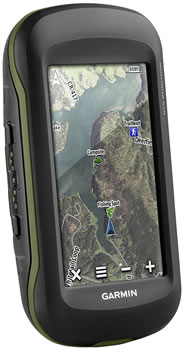 A. I would recommend the 4-inch dual-orientation touchscreen Garmin Montana 610 (pictured left).
Garmin Montana 610 handheld GPS device is the perfect partner for walking/hiking. Plus with additional maps and mounts can also be used when driving, cycling and sailing too. Featuring a 4-inch colour touchscreen, the Montana 610 can be viewed either in landscape or portrait orientation.
The Montana uses GPS and GLONASS technology to get quick, accurate GPS performance. The Montana 610 also includes a 3-axis electronic compass and barometric altimeter.
With regards walking/hiking maps, you can buy the Garmin Montana 680t 't' standing for preloaded topographical maps for Great Britain and Europe. However, the scale of these maps is between 1:100K and 1:250K (depending upon location).
If you are walking/hiking in Great Britain the better scale maps and ones which use Ordnance Survey data are:
Garmin TOPO Great Britain V3 PRO 1:50K microSD/SD card
Garmin TOPO Great Britain V3 PRO 1:25K microSD/SD card
Similar TOPO titles with better scales/detail are also available for countries within mainland Europe too.
Q. I was hoping you could give me some advice! A few friends have the Garmin Montana 600 unit which they use for trail riding and I was hoping to purchase one. I now realise this unit is no longer available so wonder what model has taken its place? I obviously want something equivalent which I would be able to get the trails which are from the 600 units my friends have as well.
A. The Garmin Montana 600 has been replaced by the Garmin Montana 610. There are however other Montana models you might also like to consider, these are:
‣Garmin Montana 680 (futures a built-in 8MB camera)
‣Garmin Montana 680t (futures a built-in 8MB camera and preloaded European maps)
To compare the Montana range please see comparison tables.
The Garmin Montana series can be used landscape or portrait view by turning the unit around and provides a large 4-inch screen which is perfect for driving and handheld use. In addition, the Montana series is compatible with the following map series.
To transfer waypoints, trails, etc you would need to download Garmin Express software on to your compatible PC.
For further information relating to Garmin Express I would recommend you speak directly to Garmin UK. While we sell the map, products, accessories, we are not Garmin and do not provide their downloadable digital services.
Q. I want to buy a GPS apparatus: is there something that could work in the car like tomtom but could also reasonably detach and act as a street guide for walking. I want it for travelling GB and France.
 A. I would recommend you take a look at the Garmin Montana series:
‣Garmin Montana 680t
‣Garmin Montana 680
‣Garmin Montana 610
The Garmin Montana series can be used landscape or portrait view by turning the unit around and provides a large 4-inch screen which is perfect for driving and handheld use. In addition, the Montana series is compatible with the following map series:
‣Garmin City Navigator NT Maps
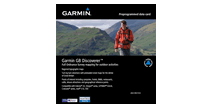
‣Garmin GB Discoverer Maps
‣Garmin TOPO Maps
‣Garmin BlueCharts
Within the map series above, there are several different UK and French maps.
Q. I have recently moved area and would like to explore all of the local footpaths, walks, hills etc. I have got lost on many walks in the past and so think a GPS would be a good idea. Not having had one before, I don't know what they consist of. (obviously I use car sat nav, so assume the walking ones offer a similar solution) Do they all come pre-loaded with maps of public footpaths etc?
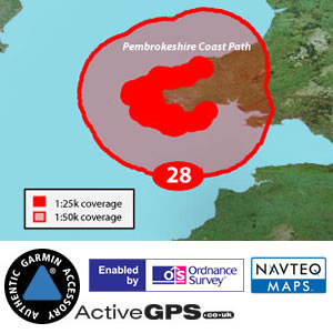 A. I’ve recently returned from a holiday in Pembrokeshire where I used a Garmin handheld device which I loaded with the OS (Ordnance Survey) GB Discoverer Maps of the Pembrokeshire Coast Path. These are at a scale of 1:25,000 which means you can zoom in to see great detail without any pixilation to the screen image – unless you zoom in even further, whereupon the (also included) street mapping takes over. Unlike the same OS paper map, where you can easily lose track of where you are, the great thing about a handheld satnav is that it will always show you exactly where you are. It will also show a line where you have walked so, if necessary, you can retrace your footsteps. You can mark ‘waypoints’ on the routes – these might be where you saw a great view or took a photograph. Each waypoint has a unique number.
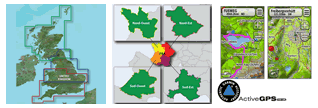
The 1:25,000 scale extends some distance outside of the designated National Park and then for a considerable distance you have access to 1:50,000 scale. Outside of that area you then have ALL of Great Britain at 1:250,000 which is still a very useful scale for OS mapping. The maps also include street level mapping for the whole of GB. I used the Pembrokeshire map but there are 30+ other maps to choose from. Scroll down at this page to view all currently available National Parks and Trails.
If you live in or near a National Park or trail this may be your best choice. Garmin have recently discontinued these maps and we are now selling residual stock. Some are already completely sold out.
There is also a 1:50,000 for ALL of Great Britain OS map.
 Then there are regional Topographical maps available but these do not show OS data.
You’ll need to buy a handheld which has a slot for a map card (for instance the eTrex 10, GPSMAP 62, Dakota 10 definitely do not have provision for a map card) and you may than want to consider screen size and whether you would want touch screen operation. Other optional features include a camera, barometric pressure, compass… None of the Garmin range come preloaded with Discoverer maps; some are preloaded with Topo maps for Europe, but usually there is just a simple base map with only basic detail.
As well as models you have mentioned it may be worth considering a Newly Overhauled (NOH) version of, for instance, the eTrex 30 – offering a reasonable saving, and still with the usual Garmin warranty.
We usually include a link to a pdf version of the appropriate instruction manual towards the bottom of each product description.
Q. Could you confirm that the Garmin GB OS Discoverer maps 1:50k are compatible with a Garmin GPSmap 60CSx? This system does not appear in the 'What is the map compatible with?'
 A. Unfortunately the Garmin GB OS Discoverer maps 1:50k are not compatible with the GPSMAP 60-series e.g. GPSMAP 60CSx.
Within the Garmin handheld GPSMAP series they are only compatible with the GPSMAP 62 and 64 series. View the latest GPSMAP range here.
Q. I am doing the Pennine Way and see you have discontinued that map. What would you recommend for my Garmin 62s?
 A. In the absence of the Pennine Way National Park map from Garmin I would recommend the GB Discoverer maps series. These give the same Ordnance Survey (OS) mapping detail but not to the same scale as the National Parks. 1:50,000 as opposed to 1:25,000.
Having used the 1:50,000 GB Discoverer mapping, in an earlier Garmin 'Colorado' handheld model, in the New Forest, North Devon and on the Pembrokeshire Coast Path. All of these locations do (or did) have a National Park map but I was satisfied with the level of detail at 1:50,000. Of course there comes a point when you zoom in too far and the detail becomes pixelated - but I do not think you would be disappointed. However, this a personal opinion and like all opinions it is subjective.
Some customers choose the regional TOPO maps showing topographical relief and some, but not all, paths and tracks: I have also used these maps but they are no substitute for the OS mapping provided by the GB Discoverer series of maps.
The area you require would be covered by the Discoverer Northern & Midlands.
However, I would recommend considering the FULL GB Discoverer map, not just because it covers the entire country (affording flexibility for future walks) but as it offers extremely good value for money, when compared to the three regional maps e.g. Discoverer Northern & Midlands.
 Q. Can I buy the Oregon 550 slip case to use with the new Oregon 600?
A. Currently there is only a soft case available for the Oregon 600 and 650. This is the smaller soft case at £10.99.
All other Oregon models from 200 – 550 have a compatible slip case (Garmin part 010-11345-00) as well as a hard case (010-10850-20). Our guess is that other websites may list these as being OK for the Oregon 600/650 range. However, the staff at Garmin UK have physically tested a new Oregon 650 with both of these cases. Whilst they DO fit, the Oregon 650 being the same size as earlier models, it is the new touch screen along with the position of buttons which has resulted in Garmin deciding not to recommend these two cases. Presumably there will ultimately be a new slip case and/or hard case for the Oregon 600/650?
Q. If I buy the GB discoverer map for my GPSMAP 62s has it actually got the Pennine Way on there? In other words, once on the Pennine Way will it have a line to follow?
 A. The GB Discoverer map of either the (discontinued) 1:25k Pennine Way or full 1:50k GB map includes Ordnance Survey (OS) mapping for the Pennine Way and surrounding area. Neither map actually includes directions or a line to follow.
It is a digital version of detailed OS maps for you to use and view in the palm of your hand.
On your GPSMAP 62s you will be able to see a "breadcrumb" (tracklog) line showing where you have been on the screen/map, add and store waypoints, (and navigate back to them if required) and you will always know exactly where you are.
For detailed information please refer to the 62s instruction manual.
 Q. Can Garmin GB Discoverer maps on SD card be used on a laptop (e.g. with BaseCamp for planning and reviewing routes)?
A. No, the SD card maps are designed to be used solely on the Garmin device e.g. Montana 650. This is to prevent copying and copyright issues.
Q. If I were to replace my Garmin GPSMAP 62s with another Garmin device, would the same SD card work on that or does it get locked to a particular device on first use?
A. Yes it would work (SD cards aren't locked to a particular device) as long as it was a device compatible with GB Discoverer mapping and has an available SD/microSD Card slot. N.B. Some models e.g. GPSMAP 62 and eTrex 10 which are both current models don't have an SD card slot at all. Plus older Garmin handheld models e.g. GPSMAP 60-series and other Garmin sat navs e.g. nuvi car sat nav range AREN’T compatible. So it is worth checking before buying another Garmin device to ensure the GB Discoverer maps are compatible.
 Q. Are there any UK map upgrades available for the Dakota 10?
A.The Garmin Dakota 10 doesn't include an SD card slot (unlike most other Garmin handhelds) for easy loading of additional maps. The only option available to you is to visit the Garmin websites and purchase maps as a download to add to the internal memory.
Q. Why are the Garmin GB Discoverer maps on SD card so expensive?
A. The SD/micro SD card where the GB Discoverer maps are stored cost pennies, the Ordnance Survey map royalty fees that is what costs the money!
To buy all the paper OS Landranger or Explorer maps separately cost a lot of money too. In this context and to have a digital copy of the map on your Garmin device - makes the device indispensable when you're using outdoors.
The entire Garmin handheld range including the above models are available to purchase from ActiveGPS.
This page was last updated on: 19th January 2026
ActiveGPS.co.uk
Customer Service
Telephone Number:
01733 777623
Monday to Friday 9:30am to 5:00pm (UK Time)
Follow us on
![]()
![]()
![]()
![]()
![]()

ActiveGPS.co.uk Copyright © Active Alliance Limited 2005-2026 | Company Number - 05200677 | VAT Number - GB 834 2222 57
Text compiled by and copyright Active Alliance Ltd. Plagiarism software in use - do not copy any of our website text, images or videos.