
Menu
Marine
Maps
Equip your boat or yacht with reliable marine GPS navigation systems from one of the UK's specialist retailers. Our range includes marine chartplotters, fishfinders, handheld marine GPS units, transducers, Navionics and Garmin BlueChart maps, and essential marine GPS accessories. We stock a wide range of Garmin marine navigation equipment for yachts, motorboats, RIBs and fishing vessels.
Choose from touchscreen chartplotters from 5" to 12", high-performance sonar fishfinders, detailed marine charts (Navionics+ & BlueChart g3), plus the cables, power kits and transducers needed to complete your installation. Enjoy UK and worldwide delivery, genuine Garmin products and expert advice when selecting your marine electronics.

Choose from 5-inch to 12-inch touchscreen marine chartplotters designed for yachts, motorboats and fishing vessels. View the latest Garmin chartplotter range.

Find fish and underwater structure using Garmin CHIRP sonar and ClearVü technology. Ideal for fishing boats, kayaks and small craft. View the latest Garmin fishfinder range.

Portable, waterproof and floating handheld marine GPS devices for sailing, kayaking, dinghies and backup navigation on larger vessels. View the latest marine handheld GPS range.

Browse genuine Garmin accessories for chartplotters, fishfinders and marine GPS systems including mounts, power cables and networking accessories. Find Garmin marine accessories.

Choose the right transducer for your boat, RIB, yacht or fishing vessel. If you're unsure which model you need, use the guides below:
‣ Transducer Selection Form
‣ Transducer Buyer's Guide
‣ View all transducers | Garmin Panoptix transducers

Browse Garmin marine charts for boats and yachts including Garmin BlueChart g3 and g3 Vision, and Navionics+ and Navionics Vision+ covering UK, European and North American waters. View Garmin marine charts.
Choosing the right marine GPS depends on the type of boat you own and how you use it. Below we explain the three main types of marine GPS units - chartplotters, fishfinders, and handheld GPS devices - and which one is best for your vessel.
 Marine Chartplotters
A chartplotter is a fixed, helm-mounted display that combines GPS navigation with digital charts. It shows your precise position overlaid on a detailed map of the water, including depth contours, hazards, harbours, and shipping lanes. Most modern chartplotters also support sonar integration, radar, autopilot connection, and AIS (Automatic Identification System) for tracking nearby vessels. A flagship example is the Garmin ECHOMAP UHD2 95sv - a 9.5-inch touchscreen chartplotter/fishfinder combo with Ultra High-Definition scanning sonar and preloaded Navionics+ UK and Ireland marine charts. Chartplotters are the best choice for yachts, motorboats, and any vessel with a permanent helm installation. Screen sizes range from 5 inches up to 12 inches and beyond.
Best for: Yachts, motorboats, cruisers, RIBs with a fixed helm, and anyone wanting integrated navigation and sonar in one display.

A fishfinder uses sonar technology to display what lies beneath your boat - fish, structure, weed beds, and seabed composition. Entry-level fishfinders use traditional CHIRP sonar, while higher-end units add DownVü (or ClearVü) for a near-photographic view directly below the hull, and SideVü for scanning to either side. A popular choice is the Garmin Striker Vivid 5cv - a compact, easy-to-use fishfinder with a bright 5-inch colour display, CHIRP sonar, and ClearVü scanning sonar included. Most fishfinders also include GPS for marking productive fishing spots as waypoints. A transducer is required to use the sonar features and is either included or purchased separately.
Best for: Anglers fishing from boats, yachts, or RIBs who want to locate fish and identify ideal fishing spots.
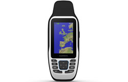
A marine handheld GPS is a portable, battery-powered device designed for use on the water. Key advantages over a fixed unit include portability, the ability to use them as a backup if your main electronics fail, and - critically - most marine handhelds float if dropped overboard. Models such as the Garmin GPSMAP 79s (pictured right) are waterproof to IPX7 standard and include preloaded BlueChart coastal maps. Note that handheld GPS units are navigation devices and do not include sonar or fishfinder capability.
Best for: Small boats and dinghies without a helm mount, sailing, kayaking, canoe touring, and as an emergency backup navigator on larger vessels.
Not sure where to start? Here's a quick guide by vessel type:
‣ CHIRP Sonar - CHIRP (Compressed High-Intensity Radiated Pulse) is the current standard for sonar on fishfinders and chartplotters. Compared to traditional sonar, CHIRP transmits a wider range of frequencies simultaneously, which produces a clearer, more detailed image of what's below - making it easier to distinguish individual fish from bottom clutter or weed. Most current Garmin fishfinders include CHIRP sonar as standard.
‣ DownVü / ClearVü - Previously called DownVü, Garmin's newer units use the term ClearVü. This feature produces a near-photographic image of the water column and seabed directly beneath your boat. It's particularly useful for identifying structure such as rocks, wrecks, and drop-offs - the kinds of features that hold fish.
‣ SideVü - SideVü scans to the left and right of the boat simultaneously, giving you a wide sonar picture of the surrounding area. This is especially valuable when searching for fish-holding structure over a wider area rather than just directly below.
‣ BlueChart g3 Maps - Garmin BlueChart g3 maps provide detailed coastal and inland waterway charts for UK and European waters. BlueChart g3 Vision versions add Auto Guidance, which automatically calculates a suggested route based on your vessel's draught - avoiding shallow water and hazards. Note: Auto Guidance requires a chartplotter and is not available on handheld GPS units.
‣ Transducers - A transducer is the underwater sensor that sends and receives the sonar signals used by fishfinders and chartplotters with sonar capability. Without a transducer, sonar features cannot function. Some units include a transducer in the box; others require one to be purchased separately. If you're unsure which transducer is compatible with your Garmin unit and boat, use our Transducer Selection Form or call us on 01733 777623.
‣ Which Garmin marine GPS units float if dropped overboard?
Garmin's marine handheld GPS units, including the Garmin GPSMAP 79s are designed to float. Fixed chartplotters and fishfinders are not designed to float. If you're on a small open boat where dropping a device overboard is a real risk, a handheld is the safer choice.
 ‣ Can I use a Garmin handheld GPS on a boat?
Yes. Garmin marine handhelds such as the Garmin GPSMAP 86i are specifically designed for on-water use, with waterproofing, floating design, and optional Garmin BlueChart coastal charts. They are fully usable as a primary navigator on small vessels and as a backup on larger ones.
‣ What are BlueChart g3 maps and do I need them?
BlueChart g3 is Garmin's range of detailed marine charts covering UK, European, and worldwide waters. They include depth contours, harbours, anchorages, tides, and hazard data. Many Garmin chartplotters come preloaded with a base map; BlueChart g3 maps add significantly more detail for coastal and offshore navigation. BlueChart g3 Vision versions additionally include Auto Guidance route planning.
‣ Can I use the same transducer for my chartplotter and fishfinder?
Yes, if both devices are connected to an NMEA 2000 network, they can share a single transducer. This is a cost-effective solution if you're installing both a chartplotter and a dedicated fishfinder on the same vessel.
‣ How do I choose the right screen size for a chartplotter?
Larger screens are easier to read at the helm and can display more chart detail simultaneously. A 5-7 inch unit suits a small RIB or secondary helm position. For a main helm display on a yacht or motorboat, a 9-12 inch screen is generally recommended. Consider the available space on your helm panel and your budget.
‣ Do you offer expert advice on which unit to buy?
Yes. Call us on 01733 777623 (Monday to Friday, 9:30am to 5:00pm) and one of our team will help you choose the right marine GPS for your vessel and how you use it. Alternatively, use our Transducer Selection Form if your main question is about sonar compatibility.
 Deliveries
We offer UK, Europe and Worldwide deliveries. We despatch orders at 4:00pm on Monday, Tuesday, Wednesday, Thursday and Friday. We need to receive your order on those days by 3:00pm. When possible we may despatch orders received after that time. No orders are despatched on Saturday, Sunday or Bank Holidays in England and Wales.
We offer FREE UK delivery on all orders of £50.00 or more, plus next working day and guaranteed Saturday delivery options. Click here for further info. All options also appear at the basket pages.
 Why Buy from ActiveGPS?
If you need help choosing between models, our team is available on 01733 777623 (Monday to Friday, 9:30am to 5:00pm).
We are official authorised Garmin Internet Retailers, offering genuine Garmin products, accessories, and maps. All our stock is purchased directly from assigned Garmin UK distributors - we do not source from the grey market and never sell counterfeit products.
When you buy from ActiveGPS.co.uk, you can be confident that you’ll receive full Garmin support and the peace of mind that comes with purchasing authentic, reliable products.
This page was last updated on: 26th October 2026