FREE UK delivery when you spend £50 - see more delivery options.

 Geocaching is an outdoor activity of electronic 'treasure hunt'. The geocacher or treasurer hunter uses a Global Positioning System (GPS) principally a handheld GPS device to locate hidden treasures at a specific GPS location. These locations are often referred to as 'caches' or 'geocaches', and more often than not the 'treasure' is plastic container containing a logbook and pen/pencil for the finder to write the date/time the geocache was discovered.
Some geocache locations also contain trinkets e.g. a small figurine or keyring, the idea is that the finder can swap out the item for another that they have.
Geocaching can be enjoyed by all ages and all you need to get started is a GPS enabled device and then follow the instructions below:
Geocaching - Getting started
 1. First log onto a website such as geocaching.com and find the latitude and longitude co-ordinates of hidden containers, called geocaches. A description of the area is also provided detailing the terrain, etc.
2. Secondly, you enter or download these co-ordinates into a GPS-enabled device and usually walk/hike to the geocache. There is usually a small gift (cuddly toy, etc.) that you take out at the cache site and replace it with something else and then you note down you were there in a log book (provided at the location).
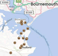
3. Finally, you share the location on the internet with other potential geocachers so that people can see how popular the geocache is. The map pictured right shows geocache locations near Bournemouth, England.
Further help and support
The Geocaching Association of Great Britain (GAGB) was set up specifically for geocaching in the UK. Established in 2003 the GAGB aims to establish good geocaching practices and provide a focal point for public liaison and supporting the growth and enjoyment of Geocaching within the UK. Please visit the Geocaching Association of Great Britain website.
Here at ActiveGPS.co.uk we sell various handheld GPS devices perfect for Geocaching. When considering which handheld GPS system to buy, it's best to consider the following: unit size, screen size and battery life. It also worth considering whether you'd like a GPS system with a monochrome or colour display, whether you'd like it to be touchscreen and finally whether you like the ability to load additional maps via SD/microSD Card such as the popular TOPO mapping series.
Below we take you through three different GPS handheld units, all perfect for geocaching, but all priced for different budgets and with different features.
Handheld/Outdoor FAQs
Do you have a question about the Garmin handheld's? Please see our handheld and Outdoor GPS FAQs page for questions from other customers.Plus if the answer to your question isn't featured, use the online form to ask us for the answer.
Garmin eTrex 10 - entry-level GPS handheld
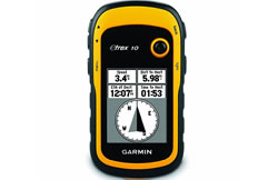 Garmin eTrex 10 is a basic handheld GPS device. It has a simple 2.2-inch monochrome display and comes preloaded with a worldwide basemap. The eTrex 10 system supports paperless geocaching so this eliminates the need for carrying paper with you showing information about each geocache site. As this device supports GPX files it will store details of each cache location such as terrain, difficulty, hints and descriptions.
It is rugged and waterproof to IPX7 standards and has a battery life of 25 hours. However, a limitation of the eTrex 10 is that there is no SD/microSD Card slot which means you can't easily upgrade the mapping on this device with a SD/microSD Card.
The Garmin eTrex 10 units dimensions are Width - 54mm, Height - 103mm, Depth - 33mm.
Garmin Oregon 750 - mid range GPS handheld
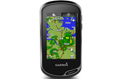 The Garmin Oregon 750 is a mid-range handheld GPS system. The screen however is currently the best available within the Garmin handheld range. The Oregon 600 features a transflective 3-inch TFT colour touchscreen display which uses technology that allows you to dim the screen and rely on sunlight instead.
The Oregon 750 system also features built-in 8 megapixel digital camera, electronic compass and barometric altimeter and can be powered via either 2x AA batteries and NiMH battery pack both providing up to 16 hours of battery life.
The Garmin Oregon 750 also supports paperless geocaching so it stores full descriptions, cache photos, hints and logs and can store up to four million geochaches!
This Oregon 750 is preprogrammed with a worldwide basemap and you can further upgrade the mapping for use on foot, on a bike, in a car or on a boat thanks to the units built-in SD/microSD Card slot. Mapping available to buy includes Topographical maps, GB Discoverer maps, City Navigator NT maps and BlueChart g3 marine charts.
The Garmin Oregon 750 units dimensions are Width - 61mm, Height - 114mm, Depth - 33mm
Garmin Montana 760i - top of the range GPS handheld
 The Garmin Montana 760i is a premium handheld device. It has a colour sunlight-readable 5-inch touchscreen. It also features a 8-megapixel camera, an electronic compass and barometric alitmeter and is waterproof to IPX7 standards. The mapping preloaded to the device is European Topographical maps. These topo maps provide rich map data with contours, elevation, roads and rivers, etc. The scale of these pre-installed topo maps is 1:100k.
Furthermore, the mapping capabilities can be expanded for use on foot, on a bike, in a car or on a boat using the units microSD card slot. These maps include Garmin topographical maps, Garmin City Navigator maps, Garmin GB Discoverer maps and Garmin BlueChart g3 marine charts.
The Garmin Montana 760i comes supplied with ra echargeable lithium-ion battery providing up to 18 hour battery life (GPS Mode); up to 330 hour battery life (Expedition Mode), up to 18 hour battery life (GPS Mode, 10 minute Tracking), up to 300 hour battery life (Expedition Mode, 30 minute Tracking).
The Garmin Montana 760i units dimensions are Width - 9.19cm, Height - 18.30cm, Depth - 3.27cm
For further help on deciding the best handheld GPS system to buy for your needs or maybe as a gift for somebody else, please see the product pages via the links to the left or by visiting the handheld GPS product range. If you have any further querstion please telephone 01733 777623 (Mon-Fri 9:30am-5pm). outside of these hours please contact us.

We are official Authorised Internet Retailers for Garmin. We sell genuine Garmin products, accessories and maps. We purchase from assigned Garmin UK distributors. We do not buy on the grey market and we do not sell counterfeit products. You can rest assured that by purchasing from ActiveGPS.co.uk you will receive the full support of Garmin.
This page was last updated on: 2nd January 2026
ActiveGPS.co.uk
Customer Service
Telephone Number:
01733 777623
Monday to Friday 9:30am to 5:00pm (UK Time)
Follow us on
![]()
![]()
![]()
![]()
![]()

ActiveGPS.co.uk Copyright © Active Alliance Limited 2005-2026 | Company Number - 05200677 | VAT Number - GB 834 2222 57
Text compiled by and copyright Active Alliance Ltd. Plagiarism software in use - do not copy any of our website text, images or videos.