FREE UK delivery when you spend £50 - see more delivery options.

Homepage / Sat Nav / Sat Nav Maps / Garmin Maps / Garmin TOPO Maps
Product Code: GARTOM8
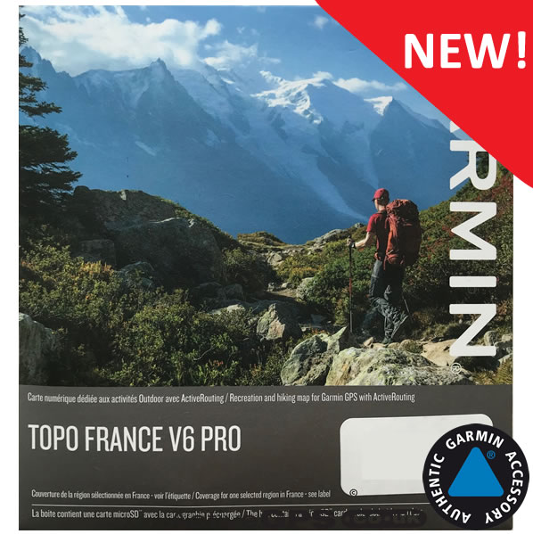
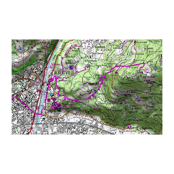
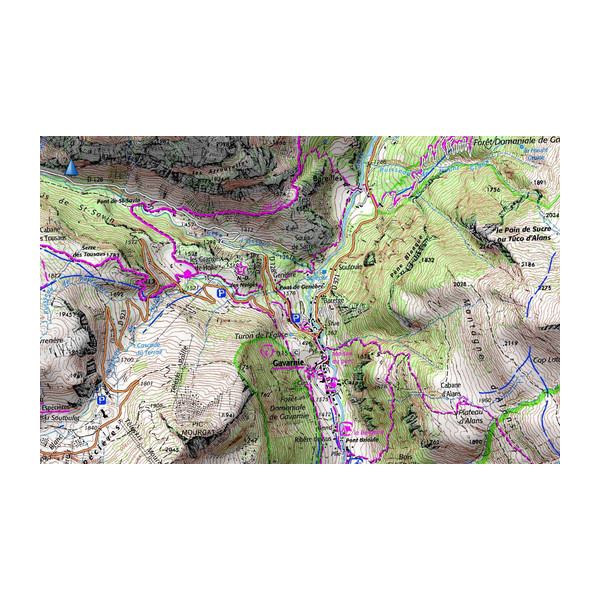
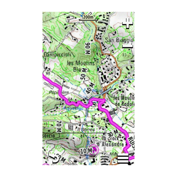
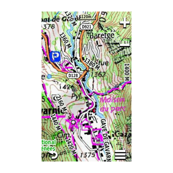
Explore the mountains of France (Alps and Pyrenees) with detailed 1:25 000 topographic IGN French maps. Garmin TOPO Pro Montagne (Mountains) includes 27,000km of FFR hiking trails and FCC mountain bike trails throughout the map coverage.
Mapping is supplied on pre-programmed microSD/SD card for easy plug-and-play use.
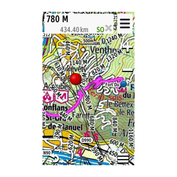
When used with a compatible Garmin handheld, car or motorcycle sat nav device the topographical map data provides essential information including; detailed land terrain contours, elevation, routable roads and rivers.
Compatibility: Compatible with Garmin Alpha 200 K, 200i K, 300 K, 300i K, Atemos 100/K 5 System, 50 and K 5, Dakota 20, Edge 800, 810, 1030, Explore 820, Touring, Touring Plus, eTrex 20, 20x, 22x, 30, 30x, 32x, Touch 25, Touch 35, GPSMAP 62s, 62sc, 62st, 62stc, 64, 64s, 64sc, 64st, 64x, 64sx, 65, 65s, 66i, 66s, 66sr, 66st, 67, 67i, 78, 78s, 78sc, 79s, 79sc, 86i, 86s, 276Cx, Montana 600, 610, 650, 650t, 680, 680t, 700, 700i, 710, 710i, 750i, 760i, Monterra, Oregon 450, 450t, 550, 550t, 600, 600t, 650, 650t, 700, 750, 750t, Tread 5.5" - Base Edition, Tread 5.5" + Group Ride Tracker, Tread 8" - Overland Edition, Tread 8" SxS Edition, Tread 10" - XL Overland Edition, zumo XT2.
Garmin part number: 010-12752-01
Please note: This is mapping software only - you need to already own (or purchase) one of the above Garmin devices. Your device may require the latest software update. Further Garmin map installation tips.
![]()
Special Order item: can take 10 days or more read more.
Garmin TOPO France V7 PRO Montagne (French Mountains) - £109.99
 Deliveries
We offer UK, Europe and Worldwide deliveries. We despatch orders at 4:30pm on Monday, Tuesday, Wednesday, Thursday and Friday. We need to receive your order on those days by 3:00pm. When possible we may despatch orders received after that time. No orders are despatched on Saturday, Sunday or Bank Holidays in England and Wales.
We offer FREE UK delivery on all orders of £50.00 or more, plus next working day and guaranteed Saturday delivery options. Click here for further info. All options also appear at the basket pages.
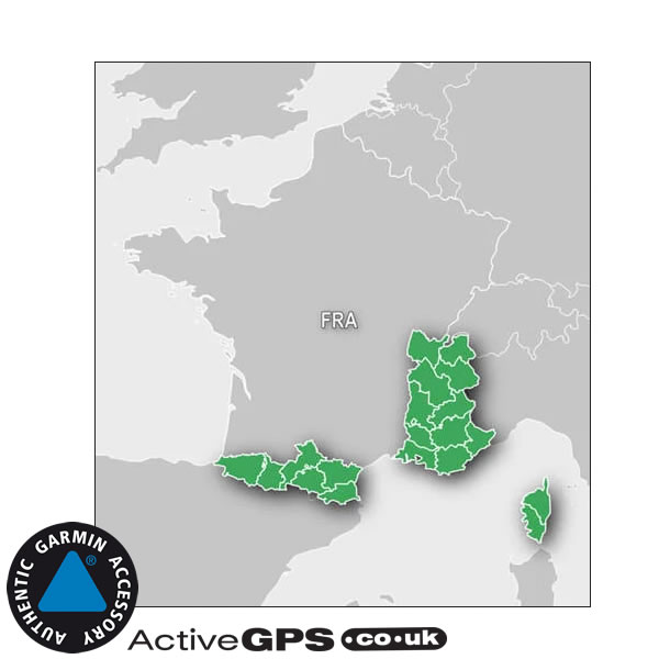
Garmin French Montagne topographical maps are the perfect partner for the compatible Garmin handheld device if you want to explore the mountains of both the Alps (South Eastern France) and Pyrenees (South Western France).
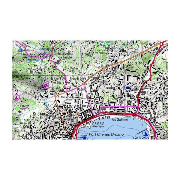
The map include detailed 1:25 000 IGN France map detail which includes contours, elevations, mountain summits, trails, paths and roads.
Topo France Montagne maps are provided on microSD/SD card.
The French Montagne topographical map the following regions and departments of France:
‣Pyrenees: 64, 65, 31, 09, 11, 66
‣Alps: 01, 74, 73, 38, 26, 05, 84, 04, 13, 83, 06
‣Corsica: 2A, 2B
The TOPO France V7 PRO Montagne map on microSD/SD card provides detailed contour and elevation information for the Alps and Pyrenees regions of France.
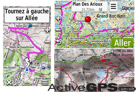
Garmin topo maps French Mountains also includes ActiveRouting which will choose the best route specific to the type of outdoor activity you are doing. You can choose from walking, hiking, mountaineering, road cycling, tour cycling and mountain biking. If you selected mountaineering it will choose a steeper, more rugged path than if you select walking.
Please note: ActiveRouting supported by BaseCamp on Windows/Mac and Montana, GPSMAP 62, 78, Edge 810, and Oregon x50, 6x0 devices.
‣Features topographic coverage for Alps and Pyrenees regions of France and Corsica
‣Includes enhanced recreation trail network, featuring detailed recreational trails, locally recognised, such as GR, GRP and PR
‣Includes searchable geographic names and business POIs, as well as searchable street addresses
‣Features a detailed Digital Elevation Model (DEM) with height contour up to 10 metre intervals
‣Features fully routable maps and Garmin ActiveRouting*
‣Provides numerous refuges and other lodging facilities from Gites d'Etape and Refuges
‣Genuine Garmin map
*Full ActiveRouting capability only with selected devices; depends on Garmin GPS device and software version.
‣SD card adaptor with preprogrammed microSD card inside
The Gar min TOPO Montagne (Mountain) map on SD/microSD Card is compatible with the following Garmin handheld devices:
Garmin Alpha 200 K, 200i K, 300 K, 300i K, Atemos 100/K 5 System, 50 and K 5, Dakota 20, Edge 800, 810, 1030, Explore 820, Touring, Touring Plus, eTrex 20, 20x, 22x, 30, 30x, 32x, Touch 25, Touch 35, GPSMAP 62s, 62sc, 62st, 62stc, 64, 64s, 64sc, 64st, 64x, 64sx, 65, 65s, 66i, 66s, 66sr, 66st, 67, 67i, 78, 78s, 78sc, 79s, 79sc, 86i, 86s, 276Cx, Montana 600, 610, 650, 650t, 680, 680t, 700, 700i, 710, 710i, 750i, 760i, Monterra, Oregon 450, 450t, 550, 550t, 600, 600t, 650, 650t, 700, 750, 750t, Tread 5.5" - Base Edition, Tread 5.5" + Group Ride Tracker, Tread 8" - Overland Edition, Tread 8" SxS Edition, Tread 10" - XL Overland Edition, zumo XT2.
![]() 'Special Order' means that an item is available but not held as a normal stock item. These items are usually obtainable within five to ten working days and we may charge Your credit/debit card/PayPal account before ordering the item from manufacturer/distributor.
'Special Order' means that an item is available but not held as a normal stock item. These items are usually obtainable within five to ten working days and we may charge Your credit/debit card/PayPal account before ordering the item from manufacturer/distributor.
IMPORTANT: Because these maps are custom ordered at time of purchase (made to order) they cannot be returned for refund and nor can the transaction be cancelled after we have ordered them from the manufacturer (in accordance with the Consumer Contracts Regulations). Therefore, please ensure that you are definitely ordering the correct map, and that you have checked that is compatible with your device, and that it will be delivered to you before you depart for your destination. If this means you need to contact us prior to ordering please do so.
TOPO French Mountains mapping comes supplied on a microSD inside a larger SD card adaptor. To install insert either the full size SD or microSD card (depending on model) into a your Garmin's SD card slot.
Once inserted, switch on your Garmin GPS system and navigate via the on-screen menu to the Maps menu screen. Once there place a tick along side the description for the new UK and Ireland map update. You have successfully installed the maps and are they are ready to use.
Please note: When using the purchased map, the SD card needs to remain in your Garmin device at all times so the map can be read. The map card cannot be copied to either your Garmin unit or external hard drive. However the map SD card can be used in multiple compatible Garmin devices, but only one at a time.
For more information, please see help with installing and loading Garmin SD/microSD Cards.
Depending upon the Garmin model that you own, there's a range of other maps that are also available. Each of the different Garmin map series below offer different features.
 Similar to topo maps, the discoverer map range provide the perfect maps for walking, hiking, etc. The difference though is in the detail - GB Discoverer mapping uses Ordnance Survey (OS) Landranger 1:50 000 maps or 1:25 000 OS Explorer map detail and appears the same on screen as the paper version. As a rule of thumb these maps are only compatible with Garmin devices post 2008, so if you own an early model you'd either need to upgrade or buy a TOPO map instead. Read more here.
 If you'd like to add street-level road maps to your Garmin system, then you need to buy a map from the Garmin City Navigator range. Most regions around the world including Full Europe (UK, Eastern and Western Europe) are now available and all maps come on plug-and-play SD/microSD Card that insert directly into your device.
To view all the maps that are available click here.
 If you'd like to use your Garmin handheld on the waters around the British Isles or abroad then you need to buy a Garmin blue chart map chip. Charts cover three different size areas from small to extra large, enabling you buy a chart for the waters that you are exploring on your boat, dinghy, yacht of RIB.
Read more about the Garmin BlueChart mapping here.

We are official Authorised Internet Retailers for Garmin. We sell genuine Garmin products, accessories and maps. We purchase from assigned Garmin UK distributors. We do not buy on the grey market and we do not sell counterfeit products. You can rest assured that by purchasing from ActiveGPS.co.uk you will receive the full support of Garmin.
This page was last updated on: 6th August 2025
ActiveGPS.co.uk
Customer Service
Telephone Number:
01733 777623
Monday to Friday 9:30am to 5:00pm (UK Time)
Follow us on
![]()
![]()
![]()
![]()
![]()

ActiveGPS.co.uk Copyright © Active Alliance Limited 2005-2025 | Company Number - 05200677 | VAT Number - GB 834 2222 57
Text compiled by and copyright Active Alliance Ltd. Plagiarism software in use - do not copy any of our website text, images or videos.