FREE UK delivery when you spend £50 - see more delivery options.

Homepage / GPS / Handheld GPS / Magellan Accessories / Magellan Maps
Product Code: MTOM3
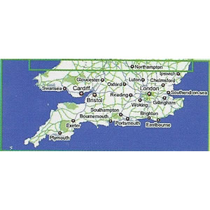
Add topographical Ordinance Survey (OS) maps on SD card of Southern England to your compatible Magellan eXplorist or Magellan Triton device, including the Magellan Triton 500, Magellan Triton 1500 and Magellan Triton 2000.
Topo Southern England provides you with all the information necessary for walking, hiking, climbing and off-road driving.
Topo UK is available in three different regions:
‣Topo UK North
‣Topo UK Mid
‣Topo UK South (the map on this page)
Compatibility: Compatible with Magellan eXplorist 400, eXplorist 500, eXplorist 600, eXplorist XL, Triton 400, Triton 500, Triton 1500, Triton 2000.
![]()
Magellan TOPO Maps of Southern England SD card - £29.99
 Deliveries
We offer UK, Europe and Worldwide deliveries. We despatch orders at 4:30pm on Monday, Tuesday, Wednesday, Thursday and Friday. We need to receive your order on those days by 3:00pm. When possible we may despatch orders received after that time. No orders are despatched on Saturday, Sunday or Bank Holidays in England and Wales.
We offer FREE UK delivery on all orders of £50.00 or more, plus next working day and guaranteed Saturday delivery options. Click here for further info. All options also appear at the basket pages.
Add topographical Ordinance Survey (OS) maps on SD card of Southern England to your compatible Magellan eXplorist or Magellan Triton device, including the Magellan Triton 500, Magellan Triton 1500 and Magellan Triton 2000.
The topo Southern England OS map includes; parks, footpaths, roads city areas, rivers, lakes and marshes. Additionally, several POI's are included, such as historical/archeological sites, places of worship, trigonometric points, camping sites, amusement parks, sports facilities, accommodation, restaurants and much more.
The data included in Topo UK is derived from Ordnance Survey, the national mapping agency of Great Britain. It is based on the latest map sets of OS MasterMap, Land-Form PROFILE and numerous POIs.
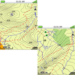
Please note: The above screenshots are taken from the Magellan Triton range.
Detailed topographic maps are also available for two additional UK regions:
‣Topo UK North
‣Topo UK Mid
‣Includes TOPO maps for Southern England
‣Designed for walking, trekking, cycling and more
‣Features topographical map data provided by Ordnance Survey
‣Includes footpaths (Private/Public), National Park boundaries, roads, rivers, lakes, campsites
‣Includes trigonometric points
‣Includes other Points Of Interest (POI)
‣Genuine Magellan Accessory
‣Preloaded SD card containing topo maps for Topo UK South (Southern England)
 What are the Magellan TOPO maps compatible with?
The Magellan topographical maps are compatible with the following Magellan handhelds:
Magellan eXplorist 400, eXplorist 500, eXplorist 600, Triton 400, Triton 500, Triton 1500, Triton 2000.
Page updated: 2nd January 2026
ActiveGPS.co.uk
Customer Service
Telephone Number:
01733 777623
Monday to Friday 9:30am to 5:00pm (UK Time)
Follow us on
![]()
![]()
![]()
![]()
![]()

ActiveGPS.co.uk Copyright © Active Alliance Limited 2005-2026 | Company Number - 05200677 | VAT Number - GB 834 2222 57
Text compiled by and copyright Active Alliance Ltd. Plagiarism software in use - do not copy any of our website text, images or videos.