FREE UK delivery when you spend £40 - see more delivery options.
Homepage / GPS / Handheld GPS / Garmin Oregon 450
Product Code: GARO450
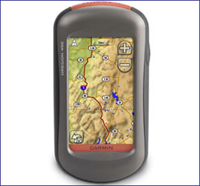
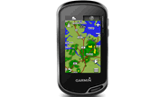
Garmin Oregon 450 combines rugged outdoor touchscreen navigation with a digital camera. The Garmin Oregon 450 includes built-in basemap, high-sensitivity receiver, barometric altimeter, electronic compass, microSD card slot, 3-inch colour display, picture viewer and more.
Garmin Oregon 450 compact high-resolution 3-inch diagonal TFT colour display handheld GPS device accepts Garmin microSD cards for adding optional maps on the go. You can even exchange tracks, waypoints, routes and geocaches wirelessly between similar units. The Garmin Oregon 450 is powered via two AA batteries.
![]()
Garmin Oregon 450 has been discontinued.
View latest handheld GPS.
Buy Garmin Oregon 450 accessories
 Deliveries
We offer UK, Europe and Worldwide deliveries. We despatch orders at 5.30pm on Monday, Tuesday, Wednesday, Thursday and Friday. We need to receive your order on those days by 4.30pm. When possible we may despatch orders received after that time. No orders are despatched after 5.30pm and no orders are despatched on Saturday or Sunday.
We offer FREE UK delivery on all orders of £40.00 or more, plus next working day and guaranteed Saturday delivery options. Click here for further info. All options also appear at the basket pages.
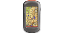
 Garmin Oregon 450 leads the way with a tough, 3-inch diagonal, sunlight-readable, colour TFT touchscreen display. Its easy-to-use interface means you’ll spend more time enjoying the outdoors and less time searching for information. Both durable and waterproof, Garmin Oregon 450 is built to withstand the elements. Bumps, dust, dirt, humidity and water are no match for this rugged navigator.
Touch and Go
Garmin Oregon 450 leads the way with a tough, 3-inch diagonal, sunlight-readable, colour, touchscreen display that offers crystal-clear enhanced colours and high-resolution images. Its easy-to-use interface means you’ll spend more time enjoying the outdoors and less time searching for information. With user-selectable dashboards, you can customise the appearance of your display. Both durable and waterproof, Garmin Oregon 450 is built to withstand the elements. Bumps, dust, dirt, humidity and water are no match for this rugged navigator.
Explore More
Garmin Oregon 450 comes with a built-in worldwide basemap with shaded contours. Simply touch the colour screen to navigate. Its digital elevation maps show you shaded contours at higher zoom levels, giving you a big picture of the surrounding terrain.
Get Your Bearings
Garmin Oregon 450 has a built-in 3-axis tilt-compensated electronic compass, which shows your heading even when you’re standing still, without holding it level. Its barometric altimeter tracks changes in pressure to pinpoint your precise altitude, and you can even use it to plot barometric pressure over time, which can help you keep an eye on changing weather conditions. See changes in your elevation ahead of you and where you've been with enhanced track navigation. With its high-sensitivity, WAAS-enabled GPS receiver and HotFix satellite prediction, Garmin Oregon 450 locates your position quickly and precisely and maintains its GPS location even in heavy tree cover and deep valleys.
Go Geocaching
Go paperless with Garmin Oregon 450 by quickly downloading information from Geocaching.com for up to 5000 caches, such as location, terrain, difficulty, hints and description.
Use for Running or Cycling
The Garmin Oregon 450 is compatible with Garmin’s heart-rate monitors and speed/cadence sensors and can track your speed, distance, elevation and location.
Share Wirelessly
With Garmin Oregon 450 you can share your waypoints, tracks, routes and geocaches wirelessly other compatible Garmin Oregon, Colorado and Dakota users. Now you can send your favourite hike to your friend to enjoy or the location of a cache to find. Sharing data is easy. Just touch “send” to transfer your information to similar units.
Do you have a question about the Garmin Oregon 450 or other handheld GPS related question that's not been answered on this webpage? Please see our handheld and Outdoor GPS FAQs page for questions from other customers.Plus if the answer to your question isn't featured, use the online form to ask us for the answer. Alternatively please telephone 01733 777623 Monday to Friday (9:30am-5:00pm) to speak to one of our sales team. For further information online please see the Garmin Oregon comparison table.
‣3-inch TFT sunlight-readable, colour, touchscreen display
‣Built-in basemap with DEM (Digital Elevation Model) data
‣Stores 1000 waypoints and 50 routes
‣Provides automatic turn-by-turn directions with optional City Navigator maps
‣High-sensitivity GPS receiver with HotFix for improved performance and reception
‣3-axis tilt-compensated electronic compass
‣Barometric altimeter
‣Easy-to-use, touchscreen interface
‣Waterproof standard: IEC 60529 IPX7
‣850MB internal memory for map data and photos
‣Wirelessly share routes, tracks, waypoints and geocaches between units
‣microSD card slot for additional map data
‣2 AA batteries (not included) provides 16 hours of use
‣Weighs 193grams with batteries
‣USB and NMEA 0183 Interface
‣1 year guarantee.
The Garmin Oregon 450 is preloaded with a worldwide basemap with shaded relief.
Add additional maps to your Garmin Oregon 450
Really bring your Garmin Oregon 450 to life with Garmin's series of mapping available on microSD/SD card, that simply plug directly into the Garmin Oregon 450 handheld GPS.
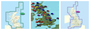
Garmin TOPO Maps
Great for walking, trekking, cycling and more with topographical data provided by Ordnance Survey and road maps provided by NAVTEQ. Garmin TOPO with detailed coverage of England, Scotland and Wales, perfect for your next recreational outing. View available Garmin Oregon 450 TOPO Maps.
Garmin GB Discoverer Maps
Explore Great Britain with detailed 1:25k or 1:50k topographic and road maps. Garmin GB Discoverer contains Ordnance Survey Landranger map coverage for either a single National Park to all of Great Britain. Plus, with NAVTEQ road data and points of interest, you'll get turn-by-turn directions to your destinations View available Garmin Oregon 450 GB Discoverer Maps.
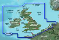 Garmin BlueChart Maps
Garmin BlueChart g2 marine maps feature crisp labeling and an overall smoother presentation on your Garmin Oregon 450 display. In addition to the basic charts, tidal stations, currents, depth contours, IALA symbols and included fishing charts, BlueChart g2 offers improved transitioning between zoom levels and more seamless continuity across chart boundaries. View available Garmin BlueChart g3 marine charts.
Garmin City Navigator NT Maps
Garmin streetlevel maps available for using with your Garmin Oregon 450 include; UK and Ireland, France and Benelux, Spain and Portugal, Germany, Italy and North America. View available Garmin Oregon 450 City Navigator NT Maps.
‣Garmin Oregon 450
‣Carabiner clip
‣USB cable
‣Owner's manual on CD-Rom
‣Quick start guide
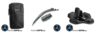
Looking for accessories to use with the Garmin Oregon 450 handheld device? We sell a vast selection of genuine parts and spares including Oregon 450 slip case, retractable lanyard, carabiner clip, bike/handlebar mount and temperature sensor.
View all Garmin Oregon 450 accessories
Optional Garmin maps for Garmin Oregon 450 are supplied on SD/microSD Card, these include; street-level road maps - perfect for cycling of using your Oregon 450 in a car, 1:50k and 1:25k Ordnance Survey maps - ideal for hiking and walking the countryside of Great Britain and marine BlueCharts g3 - ideal if you want to navigate the waters around the UK, Europe or further afield.
View all Garmin Oregon 450 maps
Question: I have a Garmin Oregon 450 GPS unit, bought in 2012. The rubber cover over the power switch has perished somewhat and broken. I am concerned it may allow water or dirt into the unit. Is it possible to buy a new cover for the switch? Is it feasible to replace it? Other than that the unit is still working fine.
Answer: While we sell Garmin Oregon 450 accessories we do not sell the rubber cover you are seeking. Can I suggest that you contact Garmin on 0808 238 0000 to enquire whether such a part is available from them?
Question: If I upgrade my gps from my Oregon 450 to a new Oregon 700 can I transfer my Garmin discovery OS whole uk 1:50k sd card?
 Answer: Yes, the Garmin GB Discoverer 1:50k all of Great Britain SD card is not fixed to anyone Garmin device. This means you can simply remove it from one Garmin unit e.g. Oregon 450 SD/microSD Card slot and insert into a different compatible Garmin units e.g. Oregon 700 microSD/SD card slot.
Had you downloaded the maps from Garmin, then these would be fixed to the Garmin device you downloaded them to.
You can purchase the Garmin Oregon 700 online here.
Do you have a question about the Garmin Oregon 450? Submit your question via our contact page.
‣Technology: GPS
‣Display: 240 x 400 pixels, 256 level color TFT
‣Waypoints: 1000
‣Routes: 50
‣Track log: 10,000 points, 20 saved tracks
‣Built-in memory: 850MB
‣Electronic compass: Yes
‣Barometric altimeter: Yes
‣Data cards: microSD card
‣Battery: 2 AA batteries (not included) up to 16 hours operation
‣Waterproof: Yes (IPX7)
‣Dimensions: Width - 58mm, Height - 114mm, Depth - 36mm
‣Weight: 193g
‣Guarantee: 1-year
‣Garmin Oregon 450 manual
![]() Manual requires Adobe Acrobat Reader
Manual requires Adobe Acrobat Reader
Download a free copy here
This product is a sophisticated electronic device which requires that you read, understand, and act upon the information given in the instruction manual (usually available via the above 'manual' link). You will need internet access and, in accordance with the manufacturers’ recommendations, regularly seek out and accept all firmware or software updates offered by the manufacturer. All GPS devices need to ‘see’ the satellites in the sky. Therefore you will need to know that your vehicle does not have glass that will block or impede the GPS signal.
Updates to this product are via the internet. At this product page we state compatibility with specific versions of current internet connection devices, for example: PC, laptop, MAC, smartphone etc. The Consumer Contract Regulations allow you 14 days, from receipt of purchase, to check compatibility with your internet connection device/s. If you choose to replace or update your PC, MAC etc. neither we nor the manufacturer will be responsible if the new/replacement Operating System (OS) is not compatible with the purchased product.
We are official Authorised Internet Retailers for Garmin. We sell genuine Garmin products, accessories and maps. We purchase from assigned Garmin UK distributors. We do not buy on the grey market and we do not sell counterfeit products. You can rest assured that by purchasing from ActiveGPS you will receive the full support of Garmin.
Page updated: 15th March 2024
ActiveGPS.co.uk
Customer Service
Telephone Number:
01733 777623
Monday to Friday 9:30am to 5:00pm (UK Time)
Follow us on
![]()
![]()
![]()
![]()
![]()

ActiveGPS.co.uk Copyright © Active Alliance Limited 2005-2024 | Company Number - 05200677 | VAT Number - GB 834 2222 57
Text compiled by and copyright Active Alliance Ltd. Plagiarism software in use - do not copy any of our website text, images or videos.