FREE UK delivery when you spend £40 - see more delivery options.
Homepage / GPS / Handheld GPS / Garmin GPSMAP 62stc
Product Code: GAR62ST
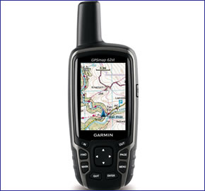
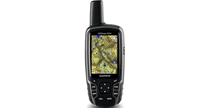
Garmin GPSMAP 62st handheld GPS system is designed for walking and hiking, however with its SD card slot you can also load additional maps making it ideal for use on a bike, on a boat and in a car too. Preprogrammed with European topographical maps, the 62st also features a 2.6-inch sunlight-readable colour screen, is waterproof and can be powered via either AA or lithium-ion batteries, providing power for up to 20 hours.
The Garmin GPSMAP 62st outdoor device also features an electronic compass and barometric altimeter.
![]()
Garmin GPSMAP 62st has been discontinued.
View latest handhelds.
The replacement and equalivent model to the Garmin GPSMAP 62st is the Garmin GPSMAP 64sx.
 Deliveries
We offer UK, Europe and Worldwide deliveries. We despatch orders at 5.30pm on Monday, Tuesday, Wednesday, Thursday and Friday. We need to receive your order on those days by 4.30pm. When possible we may despatch orders received after that time. No orders are despatched after 5.30pm and no orders are despatched on Saturday or Sunday.
We offer FREE UK delivery on all orders of £40.00 or more, plus next working day and guaranteed Saturday delivery options. Click here for further info. All options also appear at the basket pages.
 The Garmin GPSMAP 62st is a high-performing GPS handheld device - perfect for demanding outdoor adventures. With its protruding GPS receiver on top of the 62st it'll maintain a GPS satellite fix longer than other handheld GPS devices (with a built-in GPS antenna), when used in areas of poor or low GPS reception e.g. deep valleys, woodlands. Coupled with this the GPSMAP 62st is also waterproof and provides up to 20 hours battery life.
The GPSMAP 62st is part of the Garmin GPSMAP 62-series and includes the following premium features:
‣Preloaded topographical maps for Europe - the 't' in 62st
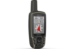
‣Electronic compass and barometric altimeter - the 's' in 62st
‣Internal 3.5GB memory
Please note: The GPSMAP 62-series supersedes the now discontinued GPSMAP 60-series, however accessories and maps are still available.
The GPSMAP 62st features a built-in 3-axis tilt-compensated electronic compass, a barometric altimeter and wireless connectivity with other compatible Garmin handheld devices. Enabling you to wirelessly share geocaches waypoints, tracks and routes. Plus with its internal 3.5GB memory you can store up to 2000 waypoints, 200 routes and 10,000 points on 200 saved tracks.
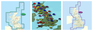
Preloaded to the premium GPSMAP 62st memory are topo maps for Europe. Topo or topographical maps provide rich map data with contours, elevation, roads and rivers, etc. The scale of these pre-installed topo maps is 1:100k.
 Additional mapping such as Garmin GB Discoverer maps are also available for use with the GPSMAP 62stc. These maps are sold separately on SD/microSD Card from ActiveGPS and once installed provide Ordnance Survey (OS) LandRanger maps at at a scale of either 1:25k or 1:50k depending on the map purchased. To view the different maps that are available for the GPSMAP 62stc click here.
Please note: You can ONLY view one map at anyone time e.g. Topo or GB Discoverer. If you are using solely in the UK and would prefer the coverage and detail that GB Discoverer (OS) maps provide, you could consider buying the GPSMAP 62sc and then purchase a GB Discoverer SD/microSD Card for the region/area of your choice.
The Garmin GPSMAP 62st supports paperless geocaching using GPX files making this an ideal handheld GPS system for geocaching. It will download coordinates of the geocache as well as the location, terrain, difficulty, hints and description. This saves you printing out the geocache details and carrying them around with you - just download to the Garmin GPSMAP device and go.
If you want a 5 megapixel digital camera built-in you should consider buying the Garmin GPSMAP 62stc instead. The 62stc which like the 62st includes the same preloaded topo maps, enables you to take photos and automatically geotags them with the GPS co-ordinates of where they were taken. This enables you to view and navigate back to exact the location too.
Do you have a question about the Garmin GPSMAP 62st or other handheld GPS related question that's not been answered on this webpage? Please see our handheld and Outdoor GPS FAQs page for questions from other customers.Plus if the answer to your question isn't featured, use the online form to ask us for the answer. Alternatively please telephone 01733 777623 Monday to Friday (9:30am-5:00pm) to speak to one of our sales team. For further information online please see the Garmin GPSMAP comparison table.
‣Bright 2.6-inch LCD sunlight readable colour display (160 x 240 pixels)
‣Preloaded European topographic map
‣Worldwide built-in basemap with shaded relief
‣High-sensitivity, WAAS/EGNOS-enable GPS receiver and HotFix
‣3-axis compass, provides accurate heading even when the unit is not level
‣Barometric altimeter tracks pressure changes to pinpoint your precise altitude and to help monitor weather
‣Rugged, waterproof (IEC 60529 IPX7)
‣3.5GB internal memory
‣Supports paperless geocaching
‣Wirelessly share thumbnails, routes, tracks, waypoints and geocaches between compatible units
‣microSD card slot for optional mapping
‣Up to 20 hours of battery life, battery type: 2 AA batteries (not included) NiMH or Lithium recommended
‣High-speed USB
‣NMEA 0183
‣1 year guarantee
Garmin GPSMAP 62st is preloaded with a worldwide basemap with shaded relief and topographic maps for Europe. Please note: Additional maps can be loaded to the GPSMAP 62st. The GPSMAP 62st features a SD/microSD Card slot, an easy way to add new maps and mapping updates.
‣Garmin GPSMAP 62st
‣Carabiner clip
‣USB cable
‣Quick start manual
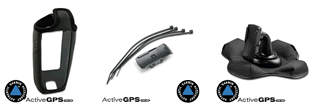
Looking for accessories to use with the Garmin GPSMAP 62st handheld device? We sell a vast selection of genuine parts and spares including GPSMAP 62st slip case, retractable lanyard, carabiner clip, bike/handlebar mount and Garmin Tempe.
View all Garmin GPSMAP 62st accessories
Garmin GPSMAP 62st is preloaded with a Worldwide basemap with shaded relief. However, a number of other maps supplied on SD/microSD Card are also compatible including street-level road maps - perfect for cycling of using your GPSMAP 62st in a car, 1:50k and 1:25k Ordnance Survey maps - ideal for hiking and walking the countryside of Great Britain and marine BlueCharts - ideal if you want to navigate the waters around the UK, Europe or further afield.
View all Garmin GPSMAP 62st maps
‣Technology: GPS
‣Display: transflective, 65-K colour TFT (160 x 240 pixels)
‣Touchscreen: No
‣Battery: 2 AA batteries (not included)
‣Waypoints/favourites/locations: 2,000
‣Routes: 200
‣Track Log: 10,000 points, 200 saved tracks
‣Basemap: Worldwide
‣Built-in memory: 400MB
‣Accepts data cards: microSD card
‣Waterproof: Yes, IPX7
‣Dimensions: Width - 61mm, Height - 160mm, Depth - 36mm
‣Weight: 260.1grams
‣Guarantee: 1-year
‣Garmin GPSMAP 62st manual
![]() Manual requires Adobe Acrobat Reader
Manual requires Adobe Acrobat Reader
Download a free copy here
This product is a sophisticated electronic device which requires that you read, understand, and act upon the information given in the instruction manual (usually available via the above 'manual' link). You will need internet access and, in accordance with the manufacturers’ recommendations, regularly seek out and accept all firmware or software updates offered by the manufacturer. All GPS devices need to ‘see’ the satellites in the sky. Therefore you will need to know that your vehicle does not have glass that will block or impede the GPS signal.
Updates to this product are via the internet. At this product page we state compatibility with specific versions of current internet connection devices, for example: PC, laptop, MAC, smartphone etc. The Consumer Contract Regulations allow you 14 days, from receipt of purchase, to check compatibility with your internet connection device/s. If you choose to replace or update your PC, MAC etc. neither we nor the manufacturer will be responsible if the new/replacement Operating System (OS) is not compatible with the purchased product.
We are official Authorised Internet Retailers for Garmin. We sell genuine Garmin products, accessories and maps. We purchase from assigned Garmin UK distributors. We do not buy on the grey market and we do not sell counterfeit products. You can rest assured that by purchasing from ActiveGPS you will receive the full support of Garmin.
Page updated: 15th March 2024
ActiveGPS.co.uk
Customer Service
Telephone Number:
01733 777623
Monday to Friday 9:30am to 5:00pm (UK Time)
Follow us on
![]()
![]()
![]()
![]()
![]()

ActiveGPS.co.uk Copyright © Active Alliance Limited 2005-2024 | Company Number - 05200677 | VAT Number - GB 834 2222 57
Text compiled by and copyright Active Alliance Ltd. Plagiarism software in use - do not copy any of our website text, images or videos.