FREE UK delivery when you spend £40 - see more delivery options.
Homepage / GPS / Marine / Chartplotters / Garmin echoMAP 70s
Product Codes: GARE70 and GARE70D
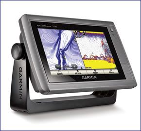
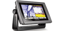
The Garmin echoMAP 70s is a standalone combination marine chartplotter and sounder GPS system. Featuring an impressive wide 7-inch WVGA multi-touchscreen display which is built into a rugged and waterproof casing. The screen has pinch-to-zoom technology and it also features GPS/GLONASS that is 10Hz which keeps your position and heading up to date 10 times per second meaning it displays fluid vessel movement.
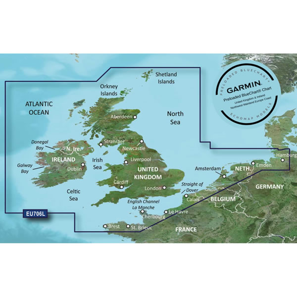
Garmin BlueChart g2 mapping covering the waters around the UK and Ireland are also included when you buy the 70s from ActiveGPS. The Garmin echoMAP 70s is also wireless compatible.
![]()
Garmin echoMAP 70s and echoMAP 70dv have both been discontinued.
View latest Chartplotters
Although both models have been discontinued, we still sell accessories for both the Garmin echoMAP 70dv and Garmin echoMAP 70s. In addition you can buy the latest Garmin marine g3 and g3 Vision BlueCharts.
 The Garmin echoMAP 70s is a combination marine chartplotter and sounder that features an impressive 7-inch WVGA display.
Part of the echoMAP series the 70s as well as offering a larger display than the smaller Garmin echoMAP 50s (which features a 5-inch display), the 70s also benefits from a touchscreen display. The 50s isn't touchscreen, but instead requires you the user to select the menus/screen via buttons located to the right hand side of the VGA display.
You can accurately mark and navigate to 5,000 waypoints, 100 routes, 50000 track log points or interest or 50 saved tracks. There is also a sonar recording capability meaning it corresponds the timing of the sonar with your boats position and saves the digital information on a map. Furthermore HD-ID target tracking means better definition of images taken with the echoMAP 70s’s Sonar. Along with all this storage and technology means you can mark fishing spots and return back to them as and when you choose to and get the best images available of whats in the water below.
The sounder defines depth contours, fish and measure depth of objects in the water up to 1900 feet or 450 metres in fresh water and 700 feet in salt water. You will need to buy a Garmin Transducer for this to work in your boat. There are three types of the transducer you can buy. These are:
‣Transom Mount - for outboard powered boats and fits to the transom of the boat.
‣In-hull mount - for non-outboard powered boats for only single skin fibre glass boats.
‣Through-hull mount - for non-outboard powered boats. For wooden, steel boats, etc.
To find the perfect transducer to partner your Garmin echoMAP 70s and your boat please complete our online transducer form. Alternatively, if you know which transducer your require (we do however recommend that you complete our online form to find the perfect transducer) you can view the comprehensive range of transducers available buy from ActiveGPS. Pictured below, transom mounted transducer, thru-hull transducer and in-hull transducer.
![]()
![]()
The echoMAP 70s also measures water temperature with a sensor (log and graph). There are even flexible brightness levels making it daytime readable and it also offers low-light dimming for night time use. Tide tables are also included with the echoMAP 70s.
The echoMAP 70s is preloaded with BlueChart g2 for the entire coastal waters of the UK and Ireland, plus Northern France, Belgium Netherlands and North West Germany which may be all you ever need.
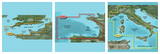
However, the echoMAP 70s also features an microSD card slot so you can load additional marine charts to the chartplotter. Also available are Garmin BlueChart g3 Vision, the g3 Vision version provides extra features including; 3D Mariners Eye for 3D information above the waterline and 3D Fish Eye for 3D information below the waterline. BlueChart g2 Vision maps also feature high-resolution satellite images for help when navigating unfamiliar waters. There is also an Auto Guidance feature that will navigate you along your chosen route avoiding shallow water, buoys and other obstacles.
Garmin g2 Vision are available in a variety of sizes from small areas e.g. Thames Estuary right up to a large area e.g. Southern Europe. Read more information about Garmin BlueChart g3 Vision charts/maps.
‣7-inch VGA display
‣Includes Garmin BlueChart g2 UK and Ireland
‣5,000 waypoints, 100 routes, 50000 track log points or interest or 50 saved tracks
‣Excellent visibility in bright sunlight and dimming for at night
‣Sonar recording
‣Sounder: 1900 feet or 450 metres in fresh water and 700 ft in salt water. (Only works when used with separate transducer)
‣HD-ID target tracking means better definition of sonar images - easier to find fish!
‣Measures water temperature (log and graph)
‣Waterproof to IPX7
‣2 microSD card slots allows upgrade to BlueChart g3 cartography and user data
‣1 Year manufacturers guarantee
Garmin echoMAP 70s marine chartplotter/chartplotter comes preloaded with Garmin BlueChart g2 UK and Ireland.
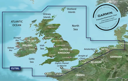
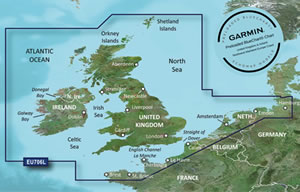
The chart (pictured above) features detailed marine cartography coverage of the British Isles in their entirety, including the Thames Estuary, Caledonian Canal, Outer Hebrides, Shetland and Orkney Islands, Isle of Wight, Isle of Man, and the Irish Sea.
Coverage across the English Channel from Douarnenez, France to Emden, Germany, including the Channel Islands, and the Seine River to Rouen, France Detailed coverage includes Antwerp, Belgium, Rotterdam, Netherlands, Amsterdam, Netherlands, and the Ijsselmeer in full. Read more information about Garmin g3 marine Bluecharts.
In future years you can purchase a marine BlueChart g3 update SD card to update the preloaded UK and Ireland charts on the Garmin echoMAP 70s/70dv.
‣Garmin echoMAP 70s
‣Preloaded Garmin BlueChart g2 UK and Ireland
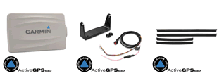
‣Power/data cable or power/data/sonar cable
‣Bail mount and knobs
‣Flush mount kit
‣Protective cover
‣Bezel
‣Documentation
Looking for Garmin echoMAP 70dv or echoMAP 70s accessories? Accessories available to purchase include 7-inch protective cover, flush mount kit and second mounting station. If you'd like to add a transducer to your echoMAP 70 please see this page.
View all Garmin echoMAP 70dv accessories
View all Garmin echoMAP 70s accessories
Add Garmin BlueChart g3 marine charts to your Garmin echoMAP 75sv, view the different Garmin g3 Bluecharts you can buy from ActiveGPS.
‣Technology: GPS
‣Display: 5-inch VGA display (480 x 640 pixels)
‣Battery: None
‣Waypoints/favourites/locations: 5,000
‣Routes: 100
‣Track Log: 50,000 points, 50 saved tracks
‣Basemap: Includes UK and Ireland mapping
‣NMEA input/output: NMEA 0183 certified
‣Built-in memory: None (cannot load maps to internal memory)
‣microSD card slot: Yes, accepts 2 microSD cards
‣Garmin radar compatible: No
‣Garmin sonar compatible: Yes
‣Waterproof: Yes, IPX7
‣Dimensions: Width - 150mm, Height - 155mm, Depth - 61mm
‣Weight: 700g
‣Guarantee: 1-year
‣Garmin echoMAP 70s manual
![]() Manual requires Adobe Acrobat Reader
Manual requires Adobe Acrobat Reader
Download a free copy here
This product is a sophisticated electronic device which requires that you read, understand, and act upon the information given in the instruction manual (usually available via the above 'manual' link). You will need internet access and, in accordance with the manufacturers’ recommendations, regularly seek out and accept all firmware or software updates offered by the manufacturer. All GPS devices need to ‘see’ the satellites in the sky. Therefore you will need to know that your vehicle does not have glass that will block or impede the GPS signal.
Updates to this product are via the internet. At this product page we state compatibility with specific versions of current internet connection devices, for example: PC, laptop, MAC, smartphone etc. The Consumer Contract Regulations allow you 14 days, from receipt of purchase, to check compatibility with your internet connection device/s. If you choose to replace or update your PC, MAC etc. neither we nor the manufacturer will be responsible if the new/replacement Operating System (OS) is not compatible with the purchased product.
We are official Authorised Internet Retailers for Garmin. We sell genuine Garmin products, accessories and maps. We purchase from assigned Garmin UK distributors. We do not buy on the grey market and we do not sell counterfeit products. You can rest assured that by purchasing from ActiveGPS you will receive the full support of Garmin.
Page updated: 15th March 2024
ActiveGPS.co.uk
Customer Service
Telephone Number:
01733 777623
Monday to Friday 9:30am to 5:00pm (UK Time)
Follow us on
![]()
![]()
![]()
![]()
![]()

ActiveGPS.co.uk Copyright © Active Alliance Limited 2005-2024 | Company Number - 05200677 | VAT Number - GB 834 2222 57
Text compiled by and copyright Active Alliance Ltd. Plagiarism software in use - do not copy any of our website text, images or videos.